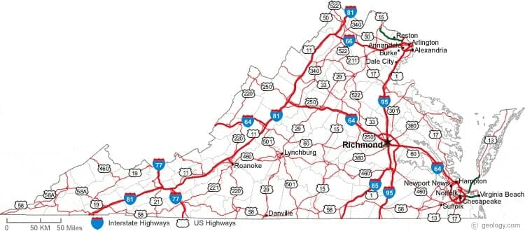
Map Primary Interstates & U.S. Highways in VA Traffic Law
Riley & Wells Attorneys-At-Law | Virginia Criminal & Traffic Defense Lawyers
 Virginia Interstates total 1,118 miles. Virginia consists of 6 primary Interstates and 10 auxiliary Interstates. Primary highways total 8111 miles and consist of U.S. Routes and primary state routes. Primary routes are generally given numbers under 600. Virginia has 48,305 miles of secondary routes. Route numbers are only unique within each county and routes that cross county lines generally keep their numbers.
***Our attorneys are licensed to practice law in all Virginia Courts***
Interstate 95 in Virginia
 Interstate 95 is the main north–south Interstate on the East Coast. I-95 is the longest north–south Interstate. I-95 runs 179 miles within Virginia through the following counties and cities: Greensville, Emporia, Sussex, Prince George, Petersburg, Colonial Heights, Chesterfield, Richmond, Henrico, Hanover, Caroline, Bowling Green, Spotsylania, Fredericksburg, Stafford, Prince William, Fairfax and Alexandria.
Interstate 81 in Virginia
 Interstate 81 is a 855 mile-long Interstate Highway. In the Commonwealth of Virginia, I-81 runs for 325 miles, making the portion in Virginia longer than any other state’s portion of the route. It stretches from Tennessee near Bristol to West Virginia and passes through the following jurisdictions: Washington, Abingdon, Smyth, Marion, Wythe, Pulaski, Montgomery, Christiansburg, Blacksburg, Roanoke, Salem, Botetourt, Fincastle, Rockbridge, Lexington, Rockingham, Harrisonburg, Shenandoah, Woodstock, Warren, Frederick, and Winchester.
Interstate 85 in Virginia
 Interstate 85 runs for 68 miles in Virginia from the North Carolina state line to I-95 in Petersburg. It is the primary connection between the Greater Richmond Region and Research Triangle. I-85 passes through the eastern part of Southside Virginia and parallels U.S. Route 1. I-85 runs through the following Virginia jurisdictions: Mecklenburg, Boydton, Brunswick, Lawrenceville, Dinwiddie and Petersburg.
Interstate 64 in Virginia
 Interstate 64 runs through Virginia for 299 miles. I-64 passes the following jurisdictions: Allegheny, Covington, Rockbridge, Augusta, Staunton, Waynesboro, Nelson, Albemarle, Charlottesville, Fluvanna, Louisa, Goochland, Henrico, Richmond, New Kent, James City, Williamsburg, York, Yorktown, Newport News, Hampton, Norfolk, Virginia Beach and Chesapeake.
Interstate 77 in Virginia
 Interstate 77 is a north–south Interstate that is 66 miles long in Virginia. I-77 traverses diverse terrain from West Virginia to North Carolina. The East River Mountain Tunnel connects Virginia and West Virginia and is one of only two instances in the United States where a mountain road tunnel crosses a state line. I-77 runs through the following Virginia jurisdictions: Carroll, Hillsville, Wythe, Wytheville & Bland.
Interstate 66 in Virginia
 Interstate 66 is a Northern Virginia Interstate that connects Frederick County with Washington, D.C.. This Interstate is 76 miles long. I-66 features a variety of high-occupancy vehicle (HOV) restrictions and toll options between US 15 in Haymarket, Virginia and the District of Columbia. I-66 runs through the following Virginia counties: Warren, Fauquier, Prince William, Manassas, Fairfax & Arlington.
Interstate 295 in Virginia
 Interstate 295 is a bypass around of the Greater Richmond Region. I-295 is 53 miles long. The road’s primary purpose is to direct long-distance travel away from downtown Richmond and Petersburg. This Interstate passes through Prince George, Hopewell, Chesterfield, Henrico, Short Pump, Glen Allen, Mechanicsville and Hanover.
Virginia State Route 288
 State Route 288 is a primary state highway in Virginia. The route begins at Interstate 95 north of Chester and extends northwesterly through Chesterfield County and Powhatan County. It crosses the James River on the World War II Veterans Memorial Bridge into Goochland County in Richmond’s Far West End area, where it terminates at Interstate 64 near Short Pump, near the northern terminus of Interstate 295.
U.S. Route 13 in Virginia
 U.S. Route 13 is a north–south highway. In Virginia, Route 13 is 129 miles long. It runs through the Hampton Roads region, which includes the cites of Suffolk, Chesapeake, Norfolk, Virginia Beach, and the Eastern Shore. On the Eastern Shore of Virginia, Route 13 is the main north–south route for the entire region, and connects Northampton, Eastville, Exmore, Cape Charles and Accomack.
U.S. Route 58 in Virginia
 U.S. Route 58 is 508 miles long and runs across the southern part of Virginia. Route 58 starts in Lee County and travels through the following Virginia jurisdictions: Washington, Bristol, Grayson, Galax, Carroll, Floyd, Patrick, Henry, Pittsylvania, Danville, Halifax, Mecklenburg, Boydton, La Crosse, Brunswick, Greensville, Emporia, Southampton, Courtland, Suffolk, Chesapeake & Virginia Beach.
U.S. Route 460 in Virginia
 U.S. Route 460 runs across the southern part of Virginia through the following jurisdictions: Buchanan, Tazewell; Giles, Montgomery, Salem, Roanoke, Botetourt, Bedford, Lynchburg, Campbell, Appomattox, Prince Edward, Nottoway, Dinwiddie, Petersburg, Prince George, Disputanta, Sussex, Waverly, Wakefield, Surry, Southampton, Ivor, Isle of Wight, Windsor, Suffolk, Chesapeake & Norfolk.
U.S. Route 360 in Virginia
 U.S. Route 360 runs 225 miles from Danville to Northumberland County. This route connects Southside Virginia with the state capital. The highway also connects the state capital with the Northern Neck. Route 360 also passes through: Pittsylvania, Halifax, Charlotte, Prince Edward, Nottoway, Amelia, Chesterfield, Henrico, Hanover, King William, King and Queen, Essex & Richmond County.
U.S. Route 29 in Virginia
 U.S. Route 29 is a north-south route in Virginia that bisects the Commonwealth into eastern and western halves. It covers 248 miles from the North Carolina border at Danville and runs through Pittsylvania, Campbell, Lynchburg, Amherst, Nelson, Albemarle, Charlottesville, Greene, Madison, Culpepper, Fauquier, Prince William, Fairfax, Falls Church & Arlington.
U.S. Route 15 in Virginia
 U.S. Route 15 is a north–south highway through the Piedmont of Virginia, connecting Clarksville and Farmville in Southside Virginia with Culpeper, Warrenton, and Leesburg in Northern Virginia. It covers 230 miles and also runs through Mecklenburg, Charlotte, Prince Edward, Farmville, Buckingham, Fluvanna, Louisa, Orange, Madison, Prince William & Loudoun.
U.S. Route 17 in Virginia
 U.S. Route 17 is a highway in the eastern half of Virginia connecting South Hampton Roads, the Middle Peninsula, the Piedmont, and the Shenandoah Valley. It runs 255.83 miles and passes through Chesapeake, Portsmouth, Suffolk, Isle of Wight, Newport News, York, Gloucester, Middlesex, Essex, Caroline, Spotsylvania, Fredericksburg, Stafford, Fauquier, Clarke, Frederick & Winchester.
U.S. Route 301 in Virginia
 U.S. Route 301 is a highway that runs from Florida to Delaware. In Virginia, it runs 142.70 miles from the North Carolina state line to the Maryland state line. This highway passes through Greenville, Emporia, Sussex, Prince George, Petersburg, Richmond, Henrico, Hanover, Caroline & King George. Route 301 runs alongside I-95 and is often concurrent with Route 1.
5/16/2018 |Updated 6/23/2024
